Advertisement

We need your help now

Support from readers like you keeps The Journal open.

You are visiting us because we have something you value. Independent, unbiased news that tells the truth. Advertising revenue goes some way to support our mission, but this year it has not been enough.

If you've seen value in our reporting, please contribute what you can, so we can continue to produce accurate and meaningful journalism. For everyone who needs it.

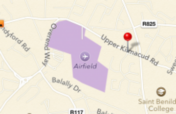
Airfield Park is a farm - but Apple's new map software, powered by Tomtom, takes the name a little too literally. Gavan Reilly/TheJournal.ie

'Alan Shatter concerned over fake Apple airport' Statement of the Day

The Minister for Justice is concerned about the error in Apple Maps, which he says could mislead pilots not familiar with the area.

WE WILL ADMIT that we had to call the Department of Justice to ensure that the statement reproduced below was genuine.

The Minister for Justice, Alan Shatter, says he has made arrangements that Apple be immediately informed of an error in the maps application in the latest version of the iPhone and iPad operating system – which incorrectly locates an airport in South Dublin.

As we noted last night, the new Apple Maps software – which replaces the Google Maps app that had previously been installed by default on all iPad and iPhone devices – takes an unfortunately literal interpretation of the placename ‘Airfield Park’.

“There are a variety of possible alternative images that could be utilised such a cow, a goat, a sheep, a flower or any indeed other type of plant as Airfield operates a nursery,” Shatter says in the statement, which is reproduced in full below.

An aircraft is an entirely inappropriate flight of imagination.

The 35-acre estate, which is currently closed for renovation, is incorrectly attributed as if it was an actual airport.

Shatter – whose Dublin South constituency includes the erroneous airport – says the designation poses a major safety concern, as the Apple Maps app could be used by pilots who are unfamiliar with the area in the case of emergency.

Given that the area houses a fully-functioning farm, the minister has some other icons which could be better used.

Here’s the statement in full:

I want to acknowledge the value of online map applications and the assistance they give to the general public. I know on occasion mistakes can be made and I am surprised to discover that Airfield, which is in the centre of my constituency in Dundrum, has,  in Apple’s new operating system iOS 6 maps application,  been designated with the image of an aircraft.  Airfield, a 35 acre estate with working farm, formal gardens and café  is of course a famous and immensely popular, important local amenity.  Clearly the designation is not only wrong but is dangerously misleading in that it could result in a pilot, unfamiliar with the area,  in an emergency situation and without other available information, attempting a landing.  I have arranged that Apple be informed of the error and requested that it be urgently corrected.  In context of Airfield there are a variety of possible alternative images that could be utilised such a cow, a goat, a sheep, a flower or any indeed other type of plant as Airfield operates a nursery.  An aircraft is an entirely inappropriate flight of imagination.

Oh dear: Apple Maps has made some pretty bad mistakes in its Ireland maps >

Picture: Dublin gets new ‘airport’ courtesy of iPhone’s new map software

Readers like you are keeping these stories free for everyone...
A mix of advertising and supporting contributions helps keep paywalls away from valuable information like this article. Over 5,000 readers like you have already stepped up and support us with a monthly payment or a once-off donation.

Close
91 Comments
    Submit a report
    Please help us understand how this comment violates our community guidelines.
    Thank you for the feedback
    Your feedback has been sent to our team for review.
    JournalTv
    News in 60 seconds