Advertisement

We need your help now

Support from readers like you keeps The Journal open.

You are visiting us because we have something you value. Independent, unbiased news that tells the truth. Advertising revenue goes some way to support our mission, but this year it has not been enough.

If you've seen value in our reporting, please contribute what you can, so we can continue to produce accurate and meaningful journalism. For everyone who needs it.

These old photos show a changing Ireland as electricity spread across the country

An interactive map lists each area connected during the rural electrification and shows when they were connected.

IT HAS BEEN 70 years since the ESB launched its Rural Electrification Scheme which promised to ‘light up the minds as well as the homes’ of people in rural Ireland.

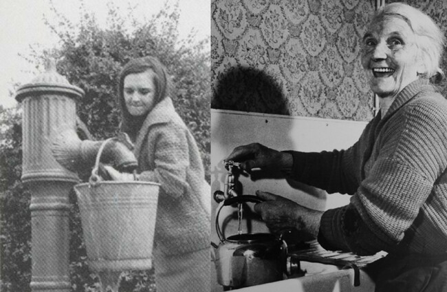
Before that water had to be carried from a well and clothes had to be washed by hand or with a hand-powered ‘wringer washer’.

Farm work and household activity were dictated by daylight and heating and cooking depended on timber and turf.

ESB has today launched a new website of its collection of photographs and maps that reveal the significant change electricity made to Irish society.

Here’s a look at just some of the images available on the site:

These old photos show a changing Ireland as electricity spread across the country
1 / 9
  • ESB

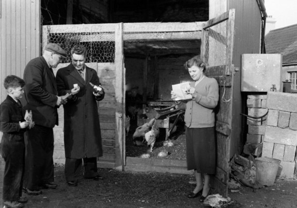
    Heating lamps for the chickens, 28 February 1956Source: ESB
  • ESB

    Cookery demonstration, c1950sSource: ESB
  • ESB

    Male demonstrator and two interested housewives, c1950sSource: ESB
  • ESB

    The delights of an egg-sorting machine, 12 September 1956Source: ESB
  • ESB

    For Modern Living’: a demonstration of the benefits of electricity in the home, 7 May 1960Source: ESB
  • ESB

    Erecting the poles, one at at timeSource: ESB
  • ESB

    Before and AfterSource: ESB
  • ESB

    Electrifying rural Ireland, 26 January 1956Source: ESB
  • ESB

    St Patricks Day Parade, c 1954Source: ESB

Ireland was divided into 792 rural areas for the process of rural electrification, 1956-1965.

Once the poles were erected, wiring connected and transformers mounted – individual houses were then connected to the grid.

ESB has released an interactive map that lists each of these and shows exactly when each area was connected.
https://www.google.com/maps/d/u/0/viewer?mid=zqZFjM97Ybmw.kdcL63IOv0Ck

The website also features photographs of inside the offices of ESB. The company made history on 17 June 1964 when Ireland’s largest computer installation went into operation.

feature-it ESB ESB

The site also features a collection of administrative records, maps, photographs, film and artefacts during the social transformation of the country.

Read: Ireland’s state power supplier is planning a major leap into solar energy>

Readers like you are keeping these stories free for everyone...
A mix of advertising and supporting contributions helps keep paywalls away from valuable information like this article. Over 5,000 readers like you have already stepped up and support us with a monthly payment or a once-off donation.

Close
29 Comments
    Submit a report
    Please help us understand how this comment violates our community guidelines.
    Thank you for the feedback
    Your feedback has been sent to our team for review.
    JournalTv
    News in 60 seconds