Advertisement

We need your help now

Support from readers like you keeps The Journal open.

You are visiting us because we have something you value. Independent, unbiased news that tells the truth. Advertising revenue goes some way to support our mission, but this year it has not been enough.

If you've seen value in our reporting, please contribute what you can, so we can continue to produce accurate and meaningful journalism. For everyone who needs it.
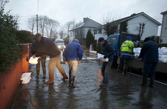
A team arrives with sandbags for a house under threat from a flooding River Shannon in the Deerpark area of Athlone Town, December 2015. Eamonn Farrell

Storms Desmond and Frank 'One year on, we need to rethink how we manage flood risk'

Our climate is warming and major flood events are likely to occur once every 10 years by the second half of this century, writes Anja Murray.

THIS TIME LAST year the country was assessing the damage caused by storms Desmond and Frank. Rivers up and down the country burst their banks. Homes, fields and roads were flooded. One year on, we need to rethink how we manage flood risk.

Our climate is warming. Major flood events, currently expected once in every 50 years, are likely to occur once every 10 years by the second half of this century. Compounding this situation is the reduced capacity of the landscape to lessen the impacts of flooding.

Topography, soil type and land use determine the rate at which water travels into river channels and thus combine to influence the tendency of a river to flood.

Profound changes in land-use since the 1960s have generally sped up the flow of water through each river catchment. Heavy rainfall therefore takes less time to reach river channels. When so much water travels quickly, there is a greater chance of rivers bursting their banks.

Urban and agricultural expansion and intensification

90404417_90404417 Eoin Butler in his parents house in Barrow Street, Graiguenamanagh in County Kilkenny, which was flooded up to four feet. Eamonn Farrell Eamonn Farrell

In recent decades, urban and agricultural expansion and intensification, often onto historic floodplains, have made floodplains and wetlands less able to deal with flooding. Hard paving in urban areas and soil compaction from intensive farming both lessen the permeability of land.

Replacing woodlands, scrub and wetlands with ploughed fields or buildings reduces the space for floodwaters to rest. Instead of allowing rivers to spill over on to floodplains during times of heavy rainfall, floodplains across the country have been drained and “reclaimed” to increase farm productivity.

Similarly, when shopping complexes or housing developments are built, land is infilled and raised to protect it from flooding. Embankments and engineered barriers add to this separation of the river from its floodplain. If we take into account the cost to wider society of these developments, we would not allow them to be built.

When water has no place to go but straight to the river channel by the quickest route

We end up having to compensate by widening and deepening channels by dredging. This has been practiced since the 1950s to reduce waterlogging so land can carry more livestock or produce higher crop yields.

A 2015 report from the Office of the Comptroller and Auditor General found that the benefits likely to be derived from carrying out such arterial drainage, in purely financial terms, are “likely to be only marginally greater than the costs”.

Because dredging often reduces local flooding, it is associated with comprehensive flood relief. However, by increasing the volume of water that passes through a channel at any given time, dredging increases flood peak and so exacerbates downstream flooding.

More flooding means that politicians and local authorities are put under pressure to allocate public money for more dredging. Rather than managing flood risk and incorporating wider catchment management, the response involves flood resistance and structural defences. By putting all our eggs in one basket, we are only increasing vulnerability in flood prone areas.

Natural flood management

90402628_90402628 An overall view of the River Shannon flowing into Athlone Town, December 2015. Sasko Lazarov Sasko Lazarov

Another approach, called “natural flood management”, is gaining recognition as a viable and cost-effective approach to flood risk management. Natural flood management takes a whole-catchment by managing soil, wetlands, woodlands and floodplains to retain water in the catchment and slow the flow at times of flood risk.

Restoration and creation of habitats such as flood meadows and reed beds can act as important stores for flood water and can help to encourage reconnection of rivers with their floodplains.

There are projects across Europe and further afield that have restored peat bogs, planted riparian woodlands, restored and created new wetlands, and re-profiled rivers and their floodplains to hold back floodwaters.

In the UK, landowners are incentivised to participate in natural flood management. This not only prompts the farmers to help alleviate flooding on a catchment scale, but can also help them deal with increased flooding while continuing to provide a source of income.

However, natural flood management is an approach that is virtually unknown in Ireland and has not been widely discussed in any relevant spheres here. There have been no trials or pilots of catchment based approaches to flood management in Ireland, despite our growing problem and hard evidence that natural flood management can be an effective means of significantly reducing flood peak.

Land-use influences the patterns of flooding

The response to flooding must involve a radical rethink of land-use policy. This means agricultural and planning policy both have a major role to play in how we adapt to a future in which storms, heavy rainfall and flooding will be much more frequent.

Natural flood management offers additional benefits to biodiversity, climate change mitigation, and water quality. Implementing natural flood management will require incentivised land-use management such as payments for woodland creation in key locations and for allowing certain lands to flood as part of a catchment based approach. Such a shift will require public support and the involvement of landowners and rural communities.

Anja Murray is an ecologist and environmental policy analyst whose research report, “Natural Flood Management: Adopting ecosystem approaches to managing flood risk”, has just been published by Friends of the Earth on www.foe.ieAnja also presents RTE’s Eco-Eye and it will be looking at the wider issues of flood risk management in its ‘Fighting Flooding’ episode on Tuesday 14th February RTE 1 at 7pm. 

Couple settle with council out-of-court after ‘appalling story’ of flooded home>

‘It absolutely destroyed me’: Man sues Laois County Council after house floods twice>

Voices

Readers like you are keeping these stories free for everyone...
A mix of advertising and supporting contributions helps keep paywalls away from valuable information like this article. Over 5,000 readers like you have already stepped up and support us with a monthly payment or a once-off donation.

View 15 comments
Close
15 Comments
    Submit a report
    Please help us understand how this comment violates our community guidelines.
    Thank you for the feedback
    Your feedback has been sent to our team for review.
    JournalTv
    News in 60 seconds