Advertisement

We need your help now

Support from readers like you keeps The Journal open.

You are visiting us because we have something you value. Independent, unbiased news that tells the truth. Advertising revenue goes some way to support our mission, but this year it has not been enough.

If you've seen value in our reporting, please contribute what you can, so we can continue to produce accurate and meaningful journalism. For everyone who needs it.
The ocean floor pics that show how the Titanic sank

New images show how the exact break-up of the Titanic might now be understood – and whether the ship had a fatal design flaw.

AN EXPEDITION TEAM which scanned the floor of the ocean where the Titanic sunk in 1912 have discovered more information about how the ship sunk to the bottom.

A series of photographs stitched together on a computer have provided a detailed photo mosaic of the debris left by the ship – and of the marks left on the ocean floor by the landing parts of the liner.

An article from Associated Press yesterday explained how the photos showed that “the stern rotated like a helicopter blade as the ship sank, rather than plunging down”. This is the first time that the extensive Titanic sinking site has been fully mapped and researchers hope it means that they will discover if there was a major flaw in its design by uncovering how exactly it broke apart and descended to the ocean floor.

We have obtained these photographs from AP today which map the site:

The ocean floor pics that show how the Titanic sank
1 / 4
  • Titanic Map

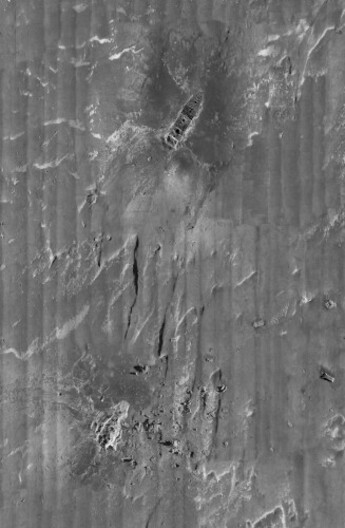
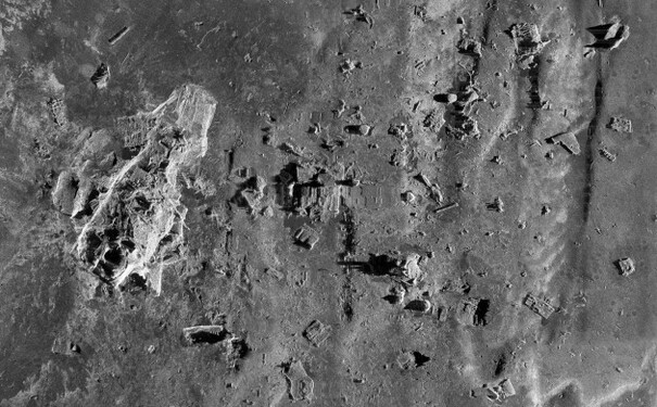
    This composite image, released by RMS Titanic Inc., and made from sonar and more than 100,000 photos taken in 2010 from by unmanned, underwater robots, shows a portion of a comprehensive map of the 3-by-5-mile debris field surrounding the bow and stern of the Titanic on the bottom of the North Atlantic Ocean. The luxury passenger liner sank about 375 miles south of Newfoundland, Canada, after striking an iceberg on its maiden voyage from England to New York on April 15, 1912, killing 1,517 people. (AP Photo/RMS Titanic Inc.)
  • Titanic Map

    This image shows the extensive area over which debris from the ship was scattered. (AP Photo/RMS Titanic Inc.)
  • Titanic Map

    This composite image, released by RMS Titanic Inc., and made from sonar and more than 100,000 photos taken in 2010 from by unmanned, underwater robots, shows a small portion of a comprehensive map of the 3-by-5-mile debris field surrounding the bow of the Titanic on the bottom of the North Atlantic Ocean. The luxury passenger liner sank about 375 miles south of Newfoundland, Canada, after striking an iceberg on its maiden voyage from England to New York on April 15, 1912, killing more than 1,500 people. (AP Photo/RMS Titanic Inc.)
  • Titanic Map

    This composite image shows zig-zag marks on the ocean floor which indicate how the debris settled as if the ship had spun down through the water rather than descending in a straight line as was previously thought. (AP Photo/RMS Titanic Inc.)

Researchers finish first complete map of Titanic debris site>
Archives show human tragedy and truth behind Titanic sinking>
Letter in a bottle from Irish Titanic victim goes on display>

Readers like you are keeping these stories free for everyone...
A mix of advertising and supporting contributions helps keep paywalls away from valuable information like this article. Over 5,000 readers like you have already stepped up and support us with a monthly payment or a once-off donation.

View 25 comments
Close
25 Comments
    Submit a report
    Please help us understand how this comment violates our community guidelines.
    Thank you for the feedback
    Your feedback has been sent to our team for review.
    JournalTv
    News in 60 seconds