Advertisement

We need your help now

Support from readers like you keeps The Journal open.

You are visiting us because we have something you value. Independent, unbiased news that tells the truth. Advertising revenue goes some way to support our mission, but this year it has not been enough.

If you've seen value in our reporting, please contribute what you can, so we can continue to produce accurate and meaningful journalism. For everyone who needs it.
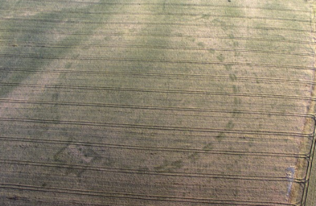
A large henge near Newgrange revealed during the dry weather. Anthony Murphy/MythicalIreland

Archaeological discoveries are being made by the dozen this summer - but what happens next?

The dry weather has revealed previously undiscovered site around the county.

“ONCE IN A lifetime stuff.” That’s how Michael MacDonagh, chief archaeologist at the National Monuments Service, describes the past month.

It’s been a month in which the extraordinarily dry and warm summer weather yielded what are some potentially revelatory historic finds across the country.

It’s happened because, as the grass in fields across the country dried out, patterns could not be seen before became visible.

Ancient holes and pits can retain trace moisture better than the soil around them, meaning that viewed from above the outline of ancient structures can be seen as darker grass.

The glut of discoveries first came to public attention when Mythical Ireland‘s Anthony Murphy and drone photographer Ken Williams found two henges near the UNESCO World Heritage Site in Newgrange, Co Meath.

Days later about two kilometres away, archaeologists revealed that excavations had uncovered the remains of a massive passage tomb at Dowth Hall.

It’s been quite a few weeks and the National Monuments Service has being dealing with a huge volume of reports from around the country.

To show just how many, MacDonagh explains that they’d usually get up to 60 or 70 reported new discoveries a year. In the last week alone, they’ve got 20.

“We are asking people to use our process, which is called monument reporting, and they can provide more locational details and allows us to check against out existing records.”

Sometimes some of the features are already known but what we’re getting in this dry weather is really new clarity on the features that are appearing in vegetation. Some of them are brand new, well obviously they’re thousands of years old, but brand new ancient discoveries. So we’re very excited by all of them and very thankful to those who have sent us in the reports.

“We’ve always used aerial photography as a means of identifying archaeological features. We’ve used that ever since we knew how to fly and had cameras. But it’s just that weather has been so extraordinarily dry, that the clarity out of the crop marks is kind of once in a lifetime stuff.”

The National Monuments Service already has over 140,000 archaeological sites listed in its records.

Many of the records of these sites are available for the public to view on archaeology.ie in the website’s Historic Environment Viewer, which shows them as dots on a map

It’s an excellent tool for anyone who wishes to explore the sites in their area, or indeed anywhere across the country.

PastedImage-94582An image from the Historical Environment Viewer of a site in Castleknock.Source: archaeology.ie

As the above image shows, each site is given a short description of what it is and its possible relevance. Doing this for the newly discovered sites is the next step for the National Monuments Service.

"We log them, try to define them, and say if they're prehistoric or medieval, for example," MacDonagh says.

"We know enough from our experience here probably what era they fit into and we'll write a description of it and we put that up on our archaeological survey of Ireland, on our sites and monuments record, and that gets put on a Historic Environment Viewer."

That's the first step but it many cases it's the only step, it's good enough to add those new sites into our record, which contains over 140,000 sites around the country and we'll continue to add into those.

"Clearly with archaeology, you never really know the full answer until you get in and excavate. But excavation is not something we leap to because excavation as a means is destructive and also the sites are on private land, and we're very protective of the landowners."

Excavation when it is carried out isn't usually done by the department, but universities may apply to begin digging with the Royal Irish Academy also running an archaeology grants scheme.

TheJournal.ie / YouTube

After last month's discoveries by drone near Newgrange, the National Monuments Service carried out its own aerial reconnaissance of the Brú na Bóinne site.

These high-resolution images are being examined by experts in an effort to get some detail together that can be shared to the public.

"We're at the original stage of mapping those and trying to come up with some good descriptions that we'll look forward to sharing with everyone," MacDonagh says.

We've informed Unesco, as we're obliged to do. But clearly our preliminary stance on this is that the discoveries are very exciting. They really have the potential to transform our understanding of that landscape, especially the flood plain of the river Boyne right in front of Newgrange.

"We always knew it was a very significant, that's why it became a Unesco World Heritage site, but these are fairly stunning additions to that and it raises the significance of the Brú na Bóinne landscape."

Close
31 Comments
This is YOUR comments community. Stay civil, stay constructive, stay on topic. Please familiarise yourself with our comments policy here before taking part.
Leave a Comment
    Submit a report
    Please help us understand how this comment violates our community guidelines.
    Thank you for the feedback
    Your feedback has been sent to our team for review.

    Leave a commentcancel