Advertisement

We need your help now

Support from readers like you keeps The Journal open.

You are visiting us because we have something you value. Independent, unbiased news that tells the truth. Advertising revenue goes some way to support our mission, but this year it has not been enough.

If you've seen value in our reporting, please contribute what you can, so we can continue to produce accurate and meaningful journalism. For everyone who needs it.
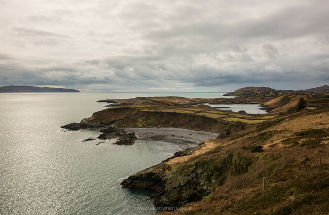
The coast of Bere Island. Neil Jackman

One for the weekend: A trip around the historic Beara peninsula

Exclusive extract from archaeologist Neil Jackman’s new book about the historical treasures of the Wild Atlantic Way.

WHETHER WREATHED IN mist and cloud or almost glowing under the sun, the landscape of the Beara Peninsula is a truly unforgettable place. A place full of folklore and legends, home to An Cailleach Béara, who according to folk tradition, lived seven times before she turned to stone.

The rugged peninsula abounds with archaeological monuments, and it is particularly rich in prehistoric heritage with numerous stone circles, megalithic tombs and standing stones. In the medieval period, it became the territory of the O’Sullivan Beare lordship, who controlled the waters around Beara with armed galleys until the last O’Sullivan Beare was expelled following the Battle of Kinsale.

During the 17th, 18th and 19th centuries, it became a place of plantation and later a focus for British military might as they sought to fortify and protect the strategic harbours of the area. I recommend starting your journey by taking the ferry from Castletownbere to Bere Island.

The story of Bere Island is shaped by the waters that surround it. Following the attempted landing at Bantry Bay by French forces in support of the Rebellion of 1798, the British began to invest in fortifying the entire bay, particularly around the valuable anchorage at Berehaven. During 1805, four Martello towers, artillery batteries, an officers’ barracks and a signal tower were constructed on Bere Island, and the island continued to be fortified at great expense throughout the first decade of the 19th century.

However, the necessity to continue the costly defensive development began to wane following the final defeat of Napoleon at the Battle of Waterloo in 1815 and by 1828 the batteries were described as being dismantled and in a state of dilapidation.

A new phase of defensive development began by 1900, with the establishment of a series of defences that would protect shipping in the deep waters of Berehaven. This included Lonehort Battery, the largest artillery battery on the island. This fort developed to have a series of watchtowers, gun emplacements, ammunition stores and barrack accommodation, all surrounded by a deep moat.

The name Lonehort may derive from the Viking term longphort, meaning ‘a ship enclosure’; these were often temporary fortified camps, that in some instances turned into permanent settlement. Evidence of the Vikings was discovered nearby, in the form of a boat-naust. This was a secure place where Viking ships could be pulled up onto the beach for repair or storage.

Lonehort Battery on Bere Island 1 Lonehart Battery on Bere Island. Neil Jackman Neil Jackman

Berehaven became a key station for the Royal Navy during the First World War, and it continued as a British naval port following the War of Independence, becoming one of the ‘Treaty Ports’. These ports, including Lonehort and the defences of Bere Island, were formally handed over to the Irish state in 1938.

The Beara Way Walking Trail will lead you around Bere Island to give you a closer look at the formidable defences. At present there is no access into the battery, but the local community is working hard to preserve the site and hope to open it to the public in the future.

After returning to the mainland, it is well worth visiting the stone circle Derreenataggart. Bear right at the south-western end of Castletownbere following the road onto West End Park and then the Rock. Turn left after 1km (signposted for the stone circle) and the site will be on your right after 500m with a small parking area opposite.

Positioned on level ground on the south-eastern slope of Miskish Mountain, the stone circle at Derreenataggart is another interesting example of the Bronze Age ritual landscape of Ireland’s south-west. The circle affords a lovely view over the landscape towards Bere Island. Teernahillane Ring Fort is further along the road to the north-west.

Derreenataggart Stone Circle Derreenataggart stone circle. Neil Jackman Neil Jackman

After visiting the stone circle, head back to the R572 and continue southwards through the stunning landscape all the way to the very tip of the peninsula. Here you can enjoy the unique experience of a ride in Ireland’s only cable car as you take a trip to Dursey Island. This is a quiet and scenic oasis, a haven for many seabirds, such as choughs and gannets, while the surrounding waters are frequented by whales, dolphins and basking sharks.

The island has a long history and is believed that it was once used as a Viking trading base, and a small medieval monastery was founded on the island perhaps in the early sixteenth century. An O’Sullivan castle was built on the small neighbouring island of Oileán Beag, but it was destroyed and the garrison massacred in 1602. You can also find the ruins of a signal tower built during the Napoleonic Wars.

Following your visit to Dursey Island, head back north along the R575 and stop to see a fine example of a wedge tomb at Killaugh, before continuing on to discover the story of the peninsula’s industrial history at Allihies. The south-west of Ireland has produced some of the oldest copper mines in Europe, with sites dating back to the earliest phase of the Bronze Age. Industrial copper mining in this area began in around 1812, when a landlord, John Puxley, noticed the bright malachite colouration on the promontory at Dooneen. Over time, six productive mines were established in the Allihies region.

The first attempts at extraction were with an adit, or tunnel, driven deep into the quartz lode from the pebble beach below. Later, in 1821, two shafts were sunk to get to the copper. To defeat the constant threat of flooding, Cornish steam engines were erected on site to pump water away from the works continually, and machinery was installed to crush the quartz rock to separate out the copper ore.

At their peak, the mines provided work for more than 1,500 people. Accommodation was cramped and unsanitary; occasionally more than 25 men would be packed into one small hovel. With such close conditions, disease was a constant threat and in 1832 a number died from a cholera outbreak.

Mining itself was a treacherous job, with the risk of tunnel collapse and floods, and death was a constant companion to the workers. With such dangerous conditions and with low pay, it is no surprise that a number of strikes are recorded in the history of the mines.

Allihies Copper Mine Museum (1) Allihies Copper Mine Museum. Neil Jackman Neil Jackman

The story of the mines is excellently told in the Copper Mine Museum, housed in the nineteenth-century Methodist church that once served the Cornish miners. It tells the story of copper mining at Allihies from the Bronze Age right up to the 1960s, with interesting exhibitions and artefacts. I highly recommend venturing along one of the numerous Copper Trails from the museum to see the ruins of the engine houses and mine workings.

Continue further north along the R575 (merging onto the R571) you will come to the village of Ardgroom. You can find a fine stone circle just outside the village to the north-east. Follow the R572 (Main Street) west and bear right when it turns into a Y-Junction. Follow this road up for just over 1km and turn left (signposted for the stone circle). The site will be on your right after 500m.

There is a small area to park before the site. Cross the waterlogged and muddy fields to reach the circle that stands proudly on the ridge above you. With its position at the foot of Coomacloghare Mountain and beautiful views over the landscape, it is easy to imagine why this was deemed to be a sacred place over 3,000 years ago.

You can discover more evidence of Bronze Age ritual landscapes at Cashelkeelty, just a ten-minute drive or so from Ardgroom. Park before the sign and stile that leads to the trail. The monuments are quite a walk (perhaps 30 minutes or so) through woods and then up a pretty steep slope to find the site. Here you will discover a small stone circle and standing stones, with a fantastic vista over the breathtaking landscape.

Standing Stones at Cashelkeelty Neil Jackman Neil Jackman

Further north and heading inland across the border into County Kerry, Uragh Stone Circle is well worth the visit. It is spectacularly located with a backdrop of mountains and waterfalls, and is further evidence of the importance of the peninsula during the Bronze Age.

These are just a handful of the monuments of the Beara Peninsula, it is easy to spend weeks, or even a lifetime, discovering all the stories that can be found around every corner of this wild and hauntingly beautiful landscape. You can also find a number of great places to reward yourself for a hard day’s exploration – a pint of Murphy’s in Teddy O’Sullivan’s Pub is hard to beat!

  • This extract has been reproduced with kind permission from Ireland’s Wild Atlantic Way: A Guide to its Historic Treasures by Neil Jackman, published by The Collins Press. From Kinsale in West Cork to Malin Head in County Donegal, this guidebook will lead you to 100 of Neil’s favourite heritage sites and landscapes. To order a signed copy of the book, click here.
  • Neil Jackman is an experienced archaeologist and the director of Abarta Heritage, a company that helps to tell the story of Ireland through audiobooks, and works with communities to empower them to showcase their heritage through training and mentoring. He has previously published 2016’s Ireland’s Ancient East with The Collins Press.

Readers like you are keeping these stories free for everyone...
A mix of advertising and supporting contributions helps keep paywalls away from valuable information like this article. Over 5,000 readers like you have already stepped up and support us with a monthly payment or a once-off donation.

Close
13 Comments
This is YOUR comments community. Stay civil, stay constructive, stay on topic. Please familiarise yourself with our comments policy here before taking part.
Leave a Comment
    Submit a report
    Please help us understand how this comment violates our community guidelines.
    Thank you for the feedback
    Your feedback has been sent to our team for review.

    Leave a commentcancel

     
    JournalTv
    News in 60 seconds