Advertisement

We need your help now

Support from readers like you keeps The Journal open.

You are visiting us because we have something you value. Independent, unbiased news that tells the truth. Advertising revenue goes some way to support our mission, but this year it has not been enough.

If you've seen value in our reporting, please contribute what you can, so we can continue to produce accurate and meaningful journalism. For everyone who needs it.
How Irish Rail is fighting an ‘alarming increase in erosion’ near vulnerable railway lines

Erosion on the south-east line and flooding in Ballycar exacerbated by climate change pose long-term challenges for railways.

MEASURES TO PROTECT railway lines that are at risk from coastal erosion and flooding are on track as climate scientists warn of changes to Irish coasts.

Projects to safeguard Irish railways from climate change are at early design stages, with Iarnród Éireann identifying which sections of track are most vulnerable to climate change.

However, it could be up to 10 years before the key measures being worked on are fully implemented.

A senior engineer has explained that Iarnród Éireann does not believe there is any immediate risk to tracks or passengers, but that the increase in the rate of coastal erosion near some railways is “alarming”.

As global temperatures rise, extreme sea-level events in Europe are expected to become more frequent and intense, leading to coastal flooding and sandy shorelines retreating.

The Iarnród Éireann Strategy 2027, published earlier this year identified two “notable examples” of tracks that require priority attention: the line running south from Dublin along the coastline and the Limerick-Ennis line at Ballycar in Clare.

The track between Dublin and Wexford, which lies close to the coast, is at risk from coastal erosion.

A new East Coast Railway Infrastructure Protection Programme (ECRIPP) is examining how to protect the coast and the line that runs along it, with the National Development Plan forecasting a ten-year timeline before the track is fully fortified.

The programme is currently considering which sections of the line will be addressed first.

Similarly, a project has been proposed to resolve flooding from the River Shannon in Ballycar, where the track has been unusable for extended periods.

But the project, which has yet to receive funding, would take around seven to 10 years to be implemented, according to an Iarnród Éireann spokesperson.

Coasts and climate change

Speaking to The Journal, Dr Brian Kelleher of DCU’s School of Chemical Sciences explained that “our coasts are very dynamic energetic places that are already under pressure from human influences and climate has exacerbated that”.

More storms, sea-level rise, and acidification brought by climate change pose a threat to the coast and infrastructure that it supports.

Dr Kelleher said the railway is at risk from shifts in the sea due to climate change.

“Especially in Dublin and places like Clare, they’re very vulnerable to sea-level rise, and of course those trains are on the front.”

“We need to be urgent about [coastal protection] and we not only have to monitor but we have to decide what we’re going to do, what we’re going to protect and how to do it.”

With its proximity to the coast, particularly in the south-east, Iarnród Eireann is at the centre of deliberations on how to mitigate erosion and preserve vulnerable land, and the trains that run along it.

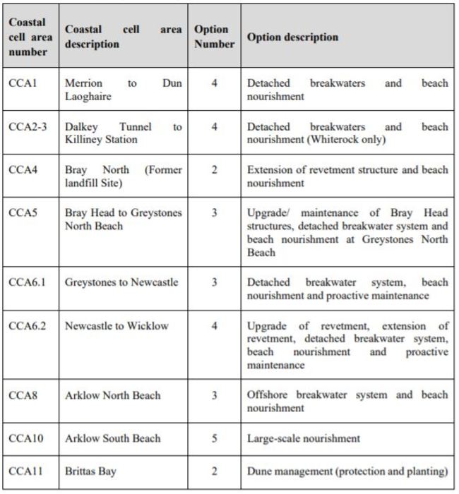
Last year, it commissioned an East Coast Erosion Study, which examined sections of track from the Merrion Gates in Sandymount to Arklow South Beach in Wicklow.

The study found every section of the line needed action through measures like detached breakwaters (which provide shelter from strong waves) and beach nourishment (which replaces eroded areas with new sand) to prevent erosion.

East Coast Erosion Study East Coast Erosion Study East Coast Erosion Study

Speaking to The Journal, ECRIPP’s Senior Programme Manager Aidan Bermingham said that “coastal erosion and climate effects are no newcomer to the railway line, especially between Dublin and Wexford”.

“It’s been an ongoing issue for the last 140 years at this stage, but what’s become quite alarming is the increase in erosion rates in recent times,” Bermingham said.

Reports from the Office of Public Works (OPW) and Irish Rail monitoring have “established that the erosion rates have increased significantly more in the last twenty years than the previous hundred years”.

“The railway is probably the first infrastructure that gets impacted by coastal effects on this stretch because we’re the closest to the sea,” Bermingham said.

“If the railway wasn’t necessarily there, we probably wouldn’t be looking at it as closely as a priority, but because the railway is there, we’ve been tasked with studying it and providing solutions going forward to try to mitigate impacts into the future.”

He said that there’s no immediate risk at present to the railway, but that some areas, such as Bray Head, would be particularly threatened if no action was taken to prevent erosion.

“At the moment, there’s no risk to the railway per se because we monitor and keep an eye on everything.

“If people think something is going to fall into the sea tomorrow, that’s not going to happen, unless we get some catastrophic storm, but we can’t plan for that. We have measures in place if something like that happens, but it’s not on the horizon.”

Currently, the ECRIPP team is working on prioritising which sections of the south-eastern line will be addressed first.

How the project plays out, and in what order, depends on factors like which areas are the most vulnerable, how funding is assigned, and project guidelines, such as whether smaller areas should be done first to learn from them before the bigger areas.

“Each of those areas are independent from the others from the coastal processes point of view. You can do one without major impact if another one didn’t go ahead depending on funding,” Bermingham said.

He said the project is seeking to align with the ten-year timeframe set out in the NDP.

“The first year or two will be design and statutory approvals and then we’ll have to look at the construction methodology.”

Many of the areas along the route, particularly south of Bray Head and Greystones, are designated as conservation or protected sites, which limits the work that can be done onshore. Instead, the mitigation measures will take effect further out to sea.

“The whole idea is to break the energy of the wave and the water mass before it hits the shore, because that’s what causes the erosion, especially south of Greystones,” Bermingham said.

“[If we] create an offshore breakwater or similar structure to dissipate the energy, the wave would hit that first, the energy would be dissipated, and by the time that water would hit the beach, the energy is reduced and that in turn reduces the erosion rate on the beach,” he said.

“Saying that, erosion will still happen, but not to the same extent as it could have happened.”

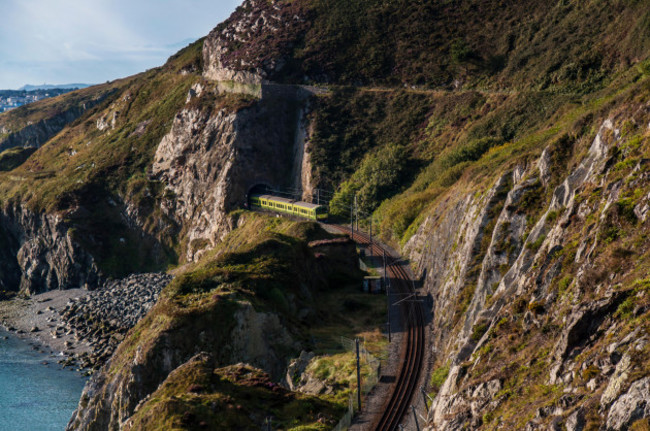
dart-train-at-bray-head-passing-through-tunnels-bray-greystones A Dart train passing through the tunnel on Bray Head Alamy Stock Photo Alamy Stock Photo

Along Bray Head, the railway is hit on two fronts: coastal erosion from the seaward side and rain run-off from the high land on the other.

The likes of Bray Head would be susceptible to long-time erosion if nothing else happened. You can see the way the tunnel has crept inland. A hundred years ago, it was 30 metres further out than what it is now.

“Bray Head tunnel is quite susceptible if no measures were put in place to reduce the erosion rate. You won’t cut it out completely – the whole idea is to reduce it and put a plan in place to monitor it.

“We do monitor it on a weekly basis in the storm season and then in the summer season on a slightly more elongated basis, and we fly it with drones to keep an eye on it as well.”

Flooded track

On the other side of the country, a community in Clare is waiting for a solution to flooding that has taken out a section of track for months at a time.

The train line between Athenry and Ennis has been partly closed on multiple occasions near Ballycar, including for five months in 2016, when water levels peaked at 1.4 metres above the rail.

Along with the south-east coast, the Iarnród Éireann Strategy 2027 identified that the Ballycar line flooding needs priority attention.

Speaking to The Journal, Clare TD Violet-Anne Wynne, said that a plan to address the flooding should have been included in the NDP.

Wynne, who co-sponsored a bill in the Dáil calling for a single River Shannon Management Agency to oversee problems such as flooding, said: “We would all have had the experience, living in Clare, that if you’re travelling from Limerick to Ennis, you would find you would have to get off the train and there would be a shuttle bus waiting to take you back to Ennis.”

“People were accommodated in that regard, but it was a nuisance. You’re talking about the middle of the winter where we’re experiencing levels of coldness and sickness as well, people having to go from the train to the bus when it could be avoidable and it’s unnecessary,” she said.

I do think that it has put people off travelling [by train], especially in the winter period, which is not the ideal scenario for society when we want to incentivise people to use public transport as much as possible and to continue to do so throughout the year, not just in those summer periods.

“It would have been proper order to have included it in the NDP and it’s a bit concerning that it wasn’t. If we’re going to look at progressing rail links in Clare, then we have to also look at the existing ones that need necessary repairs and works.”

A spokesperson for Iarnród Éireann told The Journal that the line at Ballycar was raised 0.7 metres in three works programmes between the late 1980s and 2000.

“Notwithstanding this, the frequency and severity of flood events have peaked in the past decade, illustrative of the impact of climate change on our infrastructure,” the spokesperson said.

Last year, a report was compiled by Consultant Engineers RPS looking at options for flood relief.

It recommended a drainage scheme that would prevent the occurrence of railway flooding and include any necessary flood mitigation measures downstream.

Iarnród Éireann believes that the report’s findings meet the “desired objective to identify the most appropriate technically feasible drainage solution to address the flooding at Ballycar”.

“The indicative costs for the proposed solution is €16.7 million including VAT, and for this project to proceed a funding source will need to be identified by the Exchequer,” the spokesperson said.

The report has been sent to the Department of Transport for consideration.

“When a funding source is identified, this will permit the project to progress with the steps involved including the appointment of a consultant and the progression of the project through preliminary and detailed design.

“The report notes indicative timescales for implementation of such a project are estimated to be seven to 10 years duration but will be determined by the duration of consultations, the outcome of negotiations on land acquisition, the time required to complete environmental assessment and obtain statutory approvals and permissions, design, tendering and construction.”

Caring for the coast

Dr Brian Kelleher is the Project Coordinator at PREDICT, a research programme studying Dublin Bay with a view to using the data it collects to create models that can be used to predict environmental change.

He said that we need to understand what’s happening now and forecast what’s likely to happen to be able to address problems along the coast.

“The longer we can monitor, the more data we’ll have to put into prediction or forecasting models to allow us to understand what will happen in the future and therefore adapt,” he said.

There’s going to be natural change in the coast and we need to know about that, but there’s also coastal change induced by us, by humans. The only way to understand it and to adapt is to produce data, and that’s not easy. We’ve a lot to learn in Ireland and elsewhere.

“You might put a data buoy into the ocean and have funding for three years, but three years isn’t enough. You want to leave it there for as long as possible. The longer it’s there, the more powerful the data would be.

“There needs to be an overall entity to coordinate coastal monitoring because you’re talking about lots of different disciplines from geology, geo-chemistry, oceanography – the physical, the water, the air – we really need to understand those and to monitor those to have a chance of adapting.”

Asked whether it had considered implementing such an approach, the Department of the Environment told The Journal that a sub-group of the Inter-Departmental Group on National Coastal Change Management Strategy is examining the role of state organisations on coastal work.

“The technical sub-group will bring any matters, that should be viewed in the full context of coastal change, to the group’s attention. This group is engaging with local authorities from the coastal counties and Climate Action Regional Offices to develop a combined coastal change strategy,” the department said.

“The Geological Survey Ireland (GSI) monitors Ireland’s changing coastal environment. It does so by bridging the gap between the land and the marine regions using a multidisciplinary mapping approach.”

Looking ahead at the impact of climate on Ireland’s coasts, Dr Kelleher said: “We need to act immediately. There’s absolutely no doubt about that.”

“It’s immediate, but the problem is we don’t see it that way. Humans, we just don’t look that far into the future, we need an event to get us to do something, a large event like a storm or increased storms,” he said.

“The science is extremely strong now that this is happening and we need to get urgent about it.”

This work is co-funded by Journal Media and a grant programme from the European Parliament. Any opinions or conclusions expressed in this work are the author’s own. The European Parliament has no involvement in nor responsibility for the editorial content published by the project. For more information, see here.

Readers like you are keeping these stories free for everyone...
A mix of advertising and supporting contributions helps keep paywalls away from valuable information like this article. Over 5,000 readers like you have already stepped up and support us with a monthly payment or a once-off donation.

Close
18 Comments
This is YOUR comments community. Stay civil, stay constructive, stay on topic. Please familiarise yourself with our comments policy here before taking part.
Leave a Comment
    Submit a report
    Please help us understand how this comment violates our community guidelines.
    Thank you for the feedback
    Your feedback has been sent to our team for review.

    Leave a commentcancel

     
    JournalTv
    News in 60 seconds