Advertisement

We need your help now

Support from readers like you keeps The Journal open.

You are visiting us because we have something you value. Independent, unbiased news that tells the truth. Advertising revenue goes some way to support our mission, but this year it has not been enough.

If you've seen value in our reporting, please contribute what you can, so we can continue to produce accurate and meaningful journalism. For everyone who needs it.
Paula Lyne/TheJournal.ie

Double Take: The redundant Dublin plaques that once held a very important role

There are 33 of them around the capital.

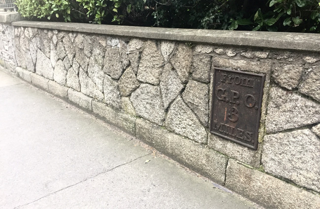
TUCKED AWAY TO the side of several of the capital’s roads are stone slabs stating the distance to the General Post Office.

Usually cut from local stone, the slabs come in various shapes and sizes, with some standing as structures in their own right, while others are set into a wall, like the photo to the right. Some were cast iron, while others were made of a combination of stone and metal. 

While they haven’t been used for their intended purpose for some 200 years and tend to fade into the background unless you happen to throw an eye upon one as you pass by, these markers once had an important – and essential – part to play in Irish society. 

Rosaleen Dwyer, County Heritage Office for South Dublin County Council, told TheJournal.ie that these milestones were once placed along roads leading to major towns or cities to inform those travelling of the distance in miles to the GPO on O’Connell Street.

Whereas today we have Google Maps to get us from A to B, these markers were introduced from the turn of the 19th century to assist postal vehicles travelling from London until the Irish transport system improved and sign posts were introduced in the 20th century.

“These roadside markers are seen today as features of heritage interest, reflecting a time when life and travelling was at a slower pace than today,” explained Rosaleen. 

“They were usually cut from local stone in various sizes and shapes, with the distance to the nearest large town engraved into the stone.”

Some were cast iron or were constructed from a combination of stone and metal, as seen in the below photo of the marker on Terenure Road East, Dublin 6.

IMG-5941 Paula Lyne / TheJournal.ie Paula Lyne / TheJournal.ie / TheJournal.ie

While many milestone markers have been lost to road widening and to residential and industrial developments, some still remain in their original locations.

“They are often included on local authority lists of protected structures, where the objective is to retain them and maintain them into the future,” said Rosaleen.

“There are six structures listed in the South Dublin County Development Plan for protection under the Record of Protected Structures; Leixlip Road, Lucan; Lucan Road; Deadman’s Inn, Old Lucan Road; Old Lucan Road, Palmerstown Lower; Old Naas Road, Brownsbarn; Ballyboden Road.”

In total, there are some 33 milestones recorded around Dublin on the list of protected structures.

If you so happen to have an unrecorded milestone in your driveway, Dublin InQuirer reports that ”the council will recommend an architect who specialises in traditional building to ensure that no accidental damage is done to it.” 

While they no longer provide the purpose for which they were introduced, they stand as a gentle reminder of how much Dublin has changed over 200 years. 

More: The easy-to-miss plaques that tell a famous Irish tale

More: The uninhabited Mayo island once owned by John Lennon

Close
Comments
This is YOUR comments community. Stay civil, stay constructive, stay on topic. Please familiarise yourself with our comments policy here before taking part.
Leave a Comment
    Submit a report
    Please help us understand how this comment violates our community guidelines.
    Thank you for the feedback
    Your feedback has been sent to our team for review.

    Leave a commentcancel