Advertisement

We need your help now

Support from readers like you keeps The Journal open.

You are visiting us because we have something you value. Independent, unbiased news that tells the truth. Advertising revenue goes some way to support our mission, but this year it has not been enough.

If you've seen value in our reporting, please contribute what you can, so we can continue to produce accurate and meaningful journalism. For everyone who needs it.
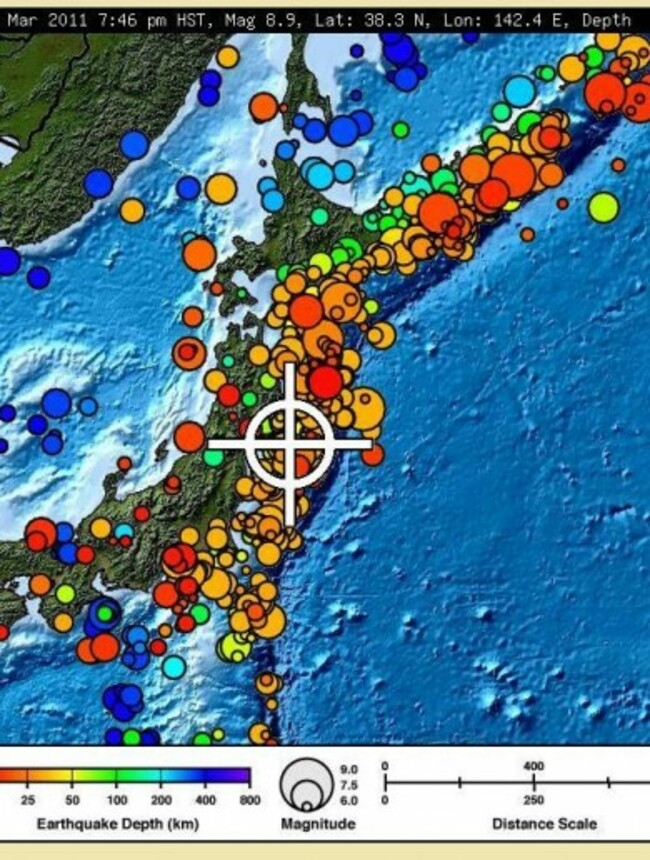
The closer to the colour red the spot is, the closer to the surface the quake focus was in this map of Japan. Image: Pacific Tsunami Warning Center.

Japan tremors incredibly close to the surface

Map shows how shallow the focus of earthquake is – red and orange spots denote shocks less than 25km from the surface.

THE CLOSER TO the surface the focus of the earthquake, the more damage it causes.

This morning’s 8.9 magnitude quake in Japan had its epicentre about 380km northeast of Tokyo, and its focus was 10km under the surfacem which is relatively shallow.

The Pacific Tsunami Warning Center, has just released this image of how the earthquake was felt in Japan. The closer to the red end of the colour spectrum the dots are, the closer to the surface the shock hit. Red is between 0-10km, orange from about 10-28km and green is around 100km. The blues denote that the focus was over 200km but no further than 600km under the surface of the earth.

Readers like you are keeping these stories free for everyone...
A mix of advertising and supporting contributions helps keep paywalls away from valuable information like this article. Over 5,000 readers like you have already stepped up and support us with a monthly payment or a once-off donation.

Close
Comments
    Submit a report
    Please help us understand how this comment violates our community guidelines.
    Thank you for the feedback
    Your feedback has been sent to our team for review.
    JournalTv
    News in 60 seconds