Advertisement

We need your help now

Support from readers like you keeps The Journal open.

You are visiting us because we have something you value. Independent, unbiased news that tells the truth. Advertising revenue goes some way to support our mission, but this year it has not been enough.

If you've seen value in our reporting, please contribute what you can, so we can continue to produce accurate and meaningful journalism. For everyone who needs it.
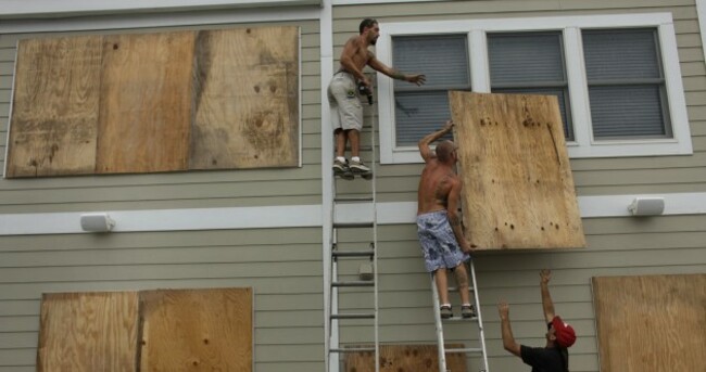
East coast residents begin preparing their homes for Hurricane Earl. Steve Earley/AP/Press Association Images

Obama declares emergency as Earl continues on its path

Hurricane watch extended to Canadian coastline.

THE EAST COAST OF AMERICA is bracing itself for force-three hurricane Earl, which continues to travels northwards towards North Carolina.

Earl weakened slightly today, but still managed winds of 125mph. Winds are spreading over 90miles from the eye of the hurricane.

The storm is expected to strike the North Carolina coast later today, prompting President Obama to declare an emergency there. In preparation, the American Red Cross is sending medical teams to the state.

US Federal Amergency Management Agency Administrator Craig Fugate said people should “not be lulled” into a false sense of security about the hurricane’s path, the Huffington Post reports.

Fugate said, “Time will be running out for people who have not gotten ready,” and neither residents nor tourists should expect the storm to steer away from areas which have been issued warnings.

The hurricane alert has now been extended to parts of New York, Massachusetts, and Canada.

Earlier today, the Guardian reported that evacuation plans were being prepared in case the hurricane moves even further ashore.

[caption id="attachment_18315" align="alignnone" width="511" caption="Satellite image of hurricane Earl taken at 6.45pm today. Here the storm sits 300 miles off the coast of North Carolina."][/caption]

Follow the storm

NASA scientists are providing live tweets on the storm’s progress on @NASAHurricane.

They have provided an excellent video describing their revolutionary hurricane monitoring system here.

The tag #earl is being used on Twitter to cover the storm.

The Washington Post has this great map charting Earl’s path, and comparing it to the course of previous storms this summer.

America’s National Oceanic and Atmospheric Administration will be posting regular updates, information and satellite images to their website.

Readers like you are keeping these stories free for everyone...
A mix of advertising and supporting contributions helps keep paywalls away from valuable information like this article. Over 5,000 readers like you have already stepped up and support us with a monthly payment or a once-off donation.

Close
JournalTv
News in 60 seconds