Advertisement

We need your help now

Support from readers like you keeps The Journal open.

You are visiting us because we have something you value. Independent, unbiased news that tells the truth. Advertising revenue goes some way to support our mission, but this year it has not been enough.

If you've seen value in our reporting, please contribute what you can, so we can continue to produce accurate and meaningful journalism. For everyone who needs it.
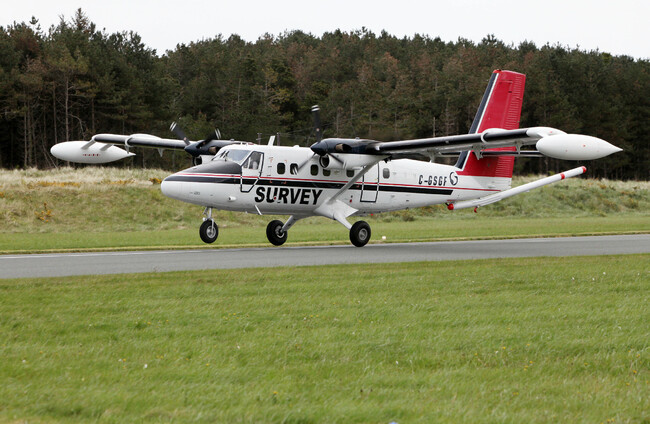
An image of the survey plane. Department of the Environment, Climate and Communications

Don't be alarmed if you spot this plane flying very low to the ground over the summer

It’s part of a geological mapping project.

IF YOU’RE IN the southwest of the country across the summer and see a low-flying plane, don’t be alarmed.

Geological Survey Ireland is conducting the ‘Tellus’ survey, focused on Kerry, Cork, and parts of Limerick.

Tellus is a national mapping programme to collect geochemical and geophysical data on rocks, soil, and water across Ireland. The survey plane will be flying at 60 metres over rural areas, and 240 metres over urban areas over the coming months.

The plane will be based at Shannon Airport. The survey will be underway from June until the end of the autumn, weather permitting. 

Geographical Survey Ireland and Tellus project manager, Dr James Hodgson, said that this would mark the “final phase of airborne surveying”.

“With over 80% of the island already covered, our team is looking forward to tackling the remaining portion of this substantial project,” he said. 

“The airborne data already produced has helped us to improve our geological maps, enhance radon risk mapping and facilitated new research on environmental pollution, agricultural productivity, and the study of peatlands.”

Speaking on Today with Claire Byrne this morning, Hodgson affirmed that the survey is not dangerous for the pilots, as they are “very well trained”.

“The pilots were joking they probably know Ireland better than anyone else because they’ve flown literally every field across the country since they started,” he said.

Having began 13 years ago, the programme aims to have 100% of Ireland mapped by the end of 2025. 

Due to the low-flying nature of the survey aircraft, Tellus have encouraged anyone concerned about sensitive livestock to contact the Tellus Freephone Information Line on 1800 45 55 65.

Geological Survey Ireland is a division of the Department of the Environment, Climate and Communications. It was founded in 1845.

Readers like you are keeping these stories free for everyone...
A mix of advertising and supporting contributions helps keep paywalls away from valuable information like this article. Over 5,000 readers like you have already stepped up and support us with a monthly payment or a once-off donation.

View 24 comments
Close
24 Comments
This is YOUR comments community. Stay civil, stay constructive, stay on topic. Please familiarise yourself with our comments policy here before taking part.
Leave a Comment
    Submit a report
    Please help us understand how this comment violates our community guidelines.
    Thank you for the feedback
    Your feedback has been sent to our team for review.

    Leave a commentcancel

     
    JournalTv
    News in 60 seconds