Advertisement

We need your help now

Support from readers like you keeps The Journal open.

You are visiting us because we have something you value. Independent, unbiased news that tells the truth. Advertising revenue goes some way to support our mission, but this year it has not been enough.

If you've seen value in our reporting, please contribute what you can, so we can continue to produce accurate and meaningful journalism. For everyone who needs it.
National Library of Ireland

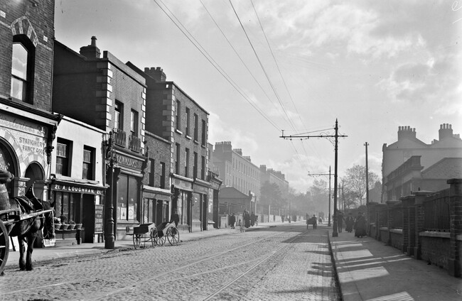
Then and now: Look at these old photos of Dublin - what pub stands there today?

Complete the quiz first, and then come back here for the then and now comparisons.

THIS IS A complementary article to this quiz.

We recommend you complete that first, and then come back to here to enjoy the then and now comparisons.

If you’ve already completed the quiz, let’s get going.

Question 1 – Gravediggers

35284885854_4bc1aa5f70_o National Library of Ireland National Library of Ireland

This is the Gravediggers in Glasnevin, as viewed from O’Connell Tower in Glasnevin Cemetery.

It’s visible at the centre left edge of the photo. See that curved wall, just beyond the tall tree? That’s still there today.

gravediggers Google Maps Google Maps

It’s a hard image to replicate, and I was wondering how I could get my hands a comparison picture for this article.

Turns out, I took one myself back in 2018 when the tower was reopened to the public.

DaqBo3UW4AAWlxQ (2) Nicky Ryan / Twitter Nicky Ryan / Twitter / Twitter

Question 2 – The Auld Triangle

37278984766_ff17fa78e8_k (1) National Library of Ireland National Library of Ireland

This one was on Dorset Street. The space filled with an ad for a ‘celebrated whiskey’ is now a H Block mural.

Trees obscure a direct recreation of this photo.

auld triangle Google Maps Google Maps

Question 3 – Crowe’s

37822014634_d7a0c4d410_o National Library of Ireland National Library of Ireland

This one was a tricky one, because there’s actually three pubs on this stretch of Merrion Road today (that is Ball’s Bridge itself in that shot, and see the RDS on the centre right?).

You can tell it’s Crowe’s and not Mary Mac’s or Paddy Cullen’s by looking at the archway behind the poll with the white stripe on the left of the image. The next fully visible building is still there. The next two have been altered, so you have where Insomia is now slightly recessed from the rest of the street, and then Crowe’s.

ballsbridge Google Maps Google Maps

Question 4 – Mother Reilly’s

37155629223_3f702222ca_o National Library of Ireland National Library of Ireland

This is Rathmines Road Upper, and Mother Reilly’s still sticks out like that – it’s the red building below.

rathmines v23 Google Maps Google Maps

Question 5 – Sinnotts Bar

31712974540_e8fd04f25a_o (1) National Library of Ireland National Library of Ireland

An utterly brilliant photo. Sadly the stunning buildings on the left were all torn down, and where the Stephen’s Green Shopping Centre is now.

grafton Google Maps Google Maps

Question 6 – Slattery’s

7459404340_3225fed78b_o (3) National Library of Ireland National Library of Ireland

Capel Street looks incredibly similar today – recognise Goodwin’s?

capel Google Maps Google Maps

Question 7 – The Hut

32224811865_7810efc8d9_o National Library National Library

A favourite of mine, just beside Doyle’s Corner in Phibsboro. Two things to note – firstly, a sign for the Bohemian is visible, but this was a cinema and not the pub of the same name across the road.

Secondly, the signs for The Hut itself are visible.

phibs2 National Library of Ireland National Library of Ireland

Here it is today.

phibs3 Google Maps Google Maps

Question 8 – The Shakespeare

6486290583_a13b12a050_o National Library of Ireland National Library of Ireland

One of the more recent photos in the quiz. Spot the retro phone box.

parnell Google Maps Google Maps

Question 9 – The Sandymount House

16426671316_233cc57670_o National Library of Ireland National Library of Ireland

Deep on the southside, here’s the Sandymount Road looking towards the green.

Sandymount Google Maps Google Maps

Question 10 – Nancy hnads

11350333074_37e16d8ca3_o National Library of Ireland National Library of Ireland

There’s also a number of pubs on stretch, but the archway just past Nancy Hands is visible in the above photo.

It’s difficult to capture this angle of Parkgate Street on Google Street View, so here’s two angles.

parkgate1 Google Maps Google Maps

parkgate2 Google Maps Google Maps

Readers like you are keeping these stories free for everyone...
A mix of advertising and supporting contributions helps keep paywalls away from valuable information like this article. Over 5,000 readers like you have already stepped up and support us with a monthly payment or a once-off donation.

Close
Comments
This is YOUR comments community. Stay civil, stay constructive, stay on topic. Please familiarise yourself with our comments policy here before taking part.
Leave a Comment
    Submit a report
    Please help us understand how this comment violates our community guidelines.
    Thank you for the feedback
    Your feedback has been sent to our team for review.

    Leave a commentcancel

     
    JournalTv
    News in 60 seconds